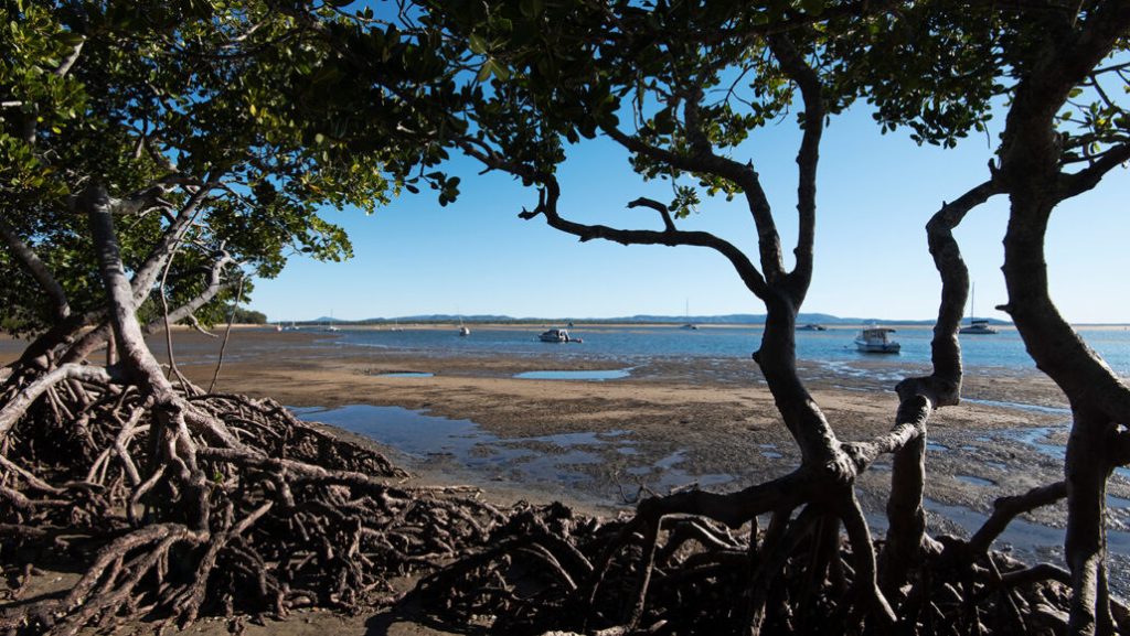
The glossy leaves and branching roots of mangroves are downright eye-catching, and now a study finds that the moon plays a special role in the vigor of these trees.
Long-term tidal cycles set in motion by the moon drive, in large part, the expansion and contraction of mangrove forests in Australia, researchers report in the Sept. 16 Science Advances. This discovery is key to predicting when stands of mangroves, which are good at sequestering carbon and could help fight climate change, are most likely to proliferate (SN: 11/18/21). Such knowledge could inform efforts to protect and restore the forests. Mangroves are coastal trees that provide habitat for fish and buffer against erosion (SN: 9/14/22). But in some places, the forests face a range of threats, including coastal development, pollution and land clearing for agriculture. To get a bird’s-eye view of these forests, Neil Saintilan, an environmental scientist at Macquarie University in Sydney, and his colleagues turned to satellite imagery. Using NASA and U.S. Geological Survey Landsat data from 1987 to 2020, the researchers calculated how the size and density of mangrove forests across Australia changed over time.
After accounting for persistent increases in these trees’ growth — probably due to rising carbon dioxide levels, higher sea levels and increasing air temperatures — Saintilan and his colleagues noticed a curious pattern. Mangrove forests tended to expand and contract in both extent and canopy cover in a predictable manner. “I saw this 18-year oscillation,” Saintilan says.
That regularity got the researchers thinking about the moon. Earth’s nearest celestial neighbor has long been known to help drive the tides, which deliver water and necessary nutrients to mangroves. A rhythm called the lunar nodal cycle could explain the mangroves’ growth pattern, the team hypothesized.
Over the course of 18.6 years, the plane of the moon’s orbit around Earth slowly tips. When the moon’s orbit is the least tilted relative to our planet’s equator, semidiurnal tides — which consist of two high and two low tides each day — tend to have a larger range. That means that in areas that experience semidiurnal tides, higher high tides and lower low tides are generally more likely. The effect is caused by the angle at which the moon tugs gravitationally on the Earth.
Saintilan and his colleagues found that mangrove forests experiencing semidiurnal tides tended to be larger and denser precisely when higher high tides were expected based on the moon’s orbit. The effect even seemed to outweigh other climatic drivers of mangrove growth, such as El Niño conditions. Other regions with mangroves, such as Vietnam and Indonesia, probably experience the same long-term trends, the team suggests.
Having access to data stretching back decades was key to this discovery, Saintilan says. “We’ve never really picked up before some of these longer-term drivers of vegetation dynamics.”
It’s important to recognize this effect on mangrove populations, says Octavio Aburto-Oropeza, a marine ecologist at the Scripps Institution of Oceanography in La Jolla, Calif., who was not involved in the research.
Scientists now know when some mangroves are particularly likely to flourish and should make an extra effort at those times to promote the growth of these carbon-sequestering trees, Aburto-Oropeza says. That might look like added limitations on human activity nearby that could harm the forests, he says. “We should be more proactive.”
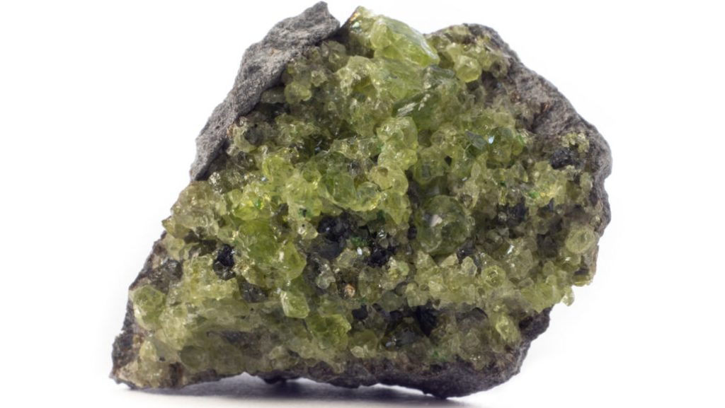
Cocooned within the bowels of the Earth, one mineral’s metamorphosis into another may trigger some of the deepest earthquakes ever detected.
These cryptic tremors — known as deep-focus earthquakes — are a seismic conundrum. They violently rupture at depths greater than 300 kilometers, where intense temperatures and pressures are thought to force rocks to flow smoothly. Now, experiments suggest that those same hellish conditions might also sometimes transform olivine — the primary mineral in Earth’s mantle — into the mineral wadsleyite. This mineral switch-up can destabilize the surrounding rock, enabling earthquakes at otherwise impossible depths, mineral physicist Tomohiro Ohuchi and colleagues report September 15 in Nature Communications. “It’s been a real puzzle for many scientists because earthquakes shouldn’t occur deeper than 300 kilometers,” says Ohuchi, of Ehime University in Matsuyama, Japan.
Deep-focus earthquakes usually occur at subduction zones where tectonic plates made of oceanic crust — rich in olivine — plunge toward the mantle (SN: 1/13/21). Since the quakes’ seismic waves lose strength during their long ascent to the surface, they aren’t typically dangerous. But that doesn’t mean the quakes aren’t sometimes powerful. In 2013, a magnitude 8.3 deep-focus quake struck around 609 kilometers below the Sea of Okhotsk, just off Russia’s eastern coast.
Past studies hinted that unstable olivine crystals could spawn deep quakes. But those studies tested other minerals that were similar in composition to olivine but deform at lower pressures, Ohuchi says, or the experiments didn’t strain samples enough to form faults.
He and his team decided to put olivine itself to the test. To replicate conditions deep underground, the researchers heated and squeezed olivine crystals up to nearly 1100° Celsius and 17 gigapascals. Then the team used a mechanical press to further compress the olivine slowly and monitored the deformation.
From 11 to 17 gigapascals and about 800° to 900° C, the olivine recrystallized into thin layers containing new wadsleyite and smaller olivine grains. The researchers also found tiny faults and recorded bursts of sound waves — indicative of miniature earthquakes. Along subducting tectonic plates, many of these thin layers grow and link to form weak regions in the rock, upon which faults and earthquakes can initiate, the researchers suggest.
“The transformation really wreaks havoc with the [rock’s] mechanical stability,” says geophysicist Pamela Burnley of the University of Nevada, Las Vegas, who was not involved in the research. The findings help confirm that olivine transformations are enabling deep-focus earthquakes, she says.
Next, Ohuchi’s team plans to experiment on olivine at even higher pressures to gain insights into the mineral’s deformation at greater depths.
The key to landing your dream job could be connecting with and then sending a single message to a casual acquaintance on social media.
That’s the conclusion of a five-year study of over 20 million users on the professional networking site LinkedIn, researchers report in the Sept. 16 Science. The study is the first large-scale effort to experimentally test a nearly 50-year-old social science theory that says weak social ties matter more than strong ones for getting ahead in life, including finding a good job. “The weak tie theory is one of the most celebrated and cited findings in social science,” says network scientist Dashun Wang of Northwestern University in Evanston, Ill., who coauthored a perspective piece in the same issue of Science. This study “provides the first causal evidence for this idea of weak ties explaining job mobility.”
Sociologist Mark Granovetter of Stanford University proposed the weak tie theory in 1973. The theory, which has garnered nearly 67,000 scientific citations, hinges on the idea that humans cluster into social spheres that connect via bridges (SN: 8/13/03). Those bridges represent weak social ties between people, and give individuals who cross access to realms of new ideas and information, including about job markets.
But the influential theory has come under fire in recent years. In particular, a 2017 analysis in the Journal of Labor Economics of 6 million Facebook users showed that increasing interaction with a friend online, thereby strengthening that social tie, increased the likelihood of working with that friend.
In the new study, LinkedIn gave Sinan Aral, a managerial economist at MIT, and his team access to data from the company’s People You May Know algorithm, which recommends new connections to users. Over five years, the social media site’s operators used seven variations of the algorithm for users actively seeking connections, each recommending varying levels of weak and strong ties to users. During that time, 2 billion new ties and 600,000 job changes were noted on the site.
Aral and his colleagues measured tie strength via the number of mutual LinkedIn connections and direct messages between users. Job transitions occurred when two criteria were met: A pair connected on LinkedIn at least one year prior to the job seeker joining the same company as the other user; and the user who first joined the company was there for at least a year before the second user came onboard. Those criteria were meant in part to weed out situations where the two could have ended up at the same company by chance. Overall, weak ties were more likely to lead to job changes than strong ones, the team found. But the study adds a twist to the theory: When job hunting, mid-tier friends are more helpful than either one’s closest friends or near strangers. Those are the friends with whom you share roughly 10 connections and seldom interact, Aral says. “They’re still weak ties, but they are not the weakest ties.”
The researchers also found that when a user added more weak ties to their network, that person applied to more jobs overall, which converted to getting more jobs. But that finding applied only to highly digitized jobs, such as those heavily reliant on software and amenable to remote work. Strong ties were more beneficial than weak ties for some job seekers outside the digital realm. Aral suspects those sorts of jobs may be more local and thus reliant on members of tight-knit communities.
The finding that job seekers should lean on mid-level acquaintances corroborates smaller studies, says network scientist Cameron Piercy of the University of Kansas in Lawrence who wasn’t involved in either the 2017 study or this more recent one.
That evidence suggests that the weakest acquaintances lack enough information about the job candidate, while the closest friends know too much about the candidate’s strengths — and flaws. “There’s this medium-ties sweet spot where you are willing to vouch for them because they know a couple people that you know,” Piercy says.
But he and others also raise ethical concerns about the new study. Piercy worries about research that manipulates people’s social media spaces without clearly and obviously indicating that it’s being done. In the new study, LinkedIn users who visited the “My Network” page for connection recommendations — who make up less than 5 percent of the site’s monthly active users — got automatically triggered into the experiment.
And it’s unclear how LinkedIn, whose researchers are coauthors of the study, will use this information moving forward. “When you are talking about people’s work, their ability to make money, this is important,” Piercy says. The company “should recommend weak ties, the version of the algorithm that led to more job attainment, if its purpose is to connect people with work. But they don’t make that conclusion in the paper.”
Another limitation is that the analyzed data lacked vital demographic information on users. That was for privacy reasons, the researchers say. But breaking down the results by gender is crucial as some evidence suggests that women — but not men — must rely on both weak and strong ties for professional advancement, Northwestern’s Wang says.
Still, with over half of jobs generally found through social ties, the findings could point people toward better ways to hunt for a job in today’s tumultuous environment. “You may have seen these recommendations on LinkedIn and you may have ignored them. You think ‘Oh, I don’t really know that person,’” Aral says. “But you may be doing yourself a disservice.”
A single, doomed moon could clear up a couple of mysteries about Saturn.
This hypothetical missing moon, dubbed Chrysalis, could have helped tilt Saturn over, researchers suggest September 15 in Science. The ensuing orbital chaos might then have led to the moon’s demise, shredding it to form the iconic rings that encircle the planet today.
“We like it because it’s a scenario that explains two or three different things that were previously not thought to be related,” says study coauthor Jack Wisdom, a planetary scientist at MIT. “The rings are related to the tilt, who would ever have guessed that?” Saturn’s rings appear surprisingly young, a mere 150 million years or so old (SN: 12/14/17). If the dinosaurs had telescopes, they might have seen a ringless Saturn. Another mysterious feature of the gas giant is its nearly 27-degree tilt relative to its orbit around the sun. That tilt is too large to have formed when Saturn did or to be the result of collisions knocking the planet over. Planetary scientists have long suspected that the tilt is related to Neptune, because of a coincidence in timing between the way the two planets move. Saturn’s axis wobbles, or precesses, like a spinning top. Neptune’s entire orbit around the sun also wobbles, like a struggling hula hoop.
The periods of both precessions are almost the same, a phenomenon known as resonance. Scientists theorized that gravity from Saturn’s moons — especially the largest moon, Titan — helped the planetary precessions line up. But some features of Saturn’s internal structure were not known well enough to prove that the two timings were related.
Wisdom and colleagues used precision measurements of Saturn’s gravitational field from the Cassini spacecraft, which plunged into Saturn in 2017 after 13 years orbiting the gas giant, to figure out the details of its internal structure (SN: 9/15/17). Specifically, the team worked out Saturn’s moment of inertia, a measure of how much force is needed to tip the planet over. The team found that the moment of inertia is close to, but not exactly, what it would be if Saturn’s spin were in perfect resonance with Neptune’s orbit.
“We argue that it’s so close, it couldn’t have occurred by chance,” Wisdom says. “That’s where this satellite Chrysalis came in.”
After considering a volley of other explanations, Wisdom and colleagues realized that another smallish moon would have helped Titan bring Saturn and Neptune into resonance by adding its own gravitational tugs. Titan drifted away from Saturn until its orbit synced up with that of Chrysalis. The enhanced gravitational kicks from the larger moon sent the doomed smaller moon on a chaotic dance. Eventually, Chrysalis swooped so close to Saturn that it grazed the giant planet’s cloud tops. Saturn ripped the moon apart, and slowly ground its pieces down into the rings.
Calculations and computer simulations showed that the scenario works, though not all the time. Out of 390 simulated scenarios, only 17 ended with Chrysalis disintegrating to create the rings. Then again, massive, striking rings like Saturn’s are rare, too.
The name Chrysalis came from that spectacular ending: “A chrysalis is a cocoon of a butterfly,” Wisdom says. “The satellite Chrysalis was dormant for 4.5 billion years, presumably. Then suddenly the rings of Saturn emerged from it.”
The story hangs together, says planetary scientist Larry Esposito of the University of Colorado Boulder, who was not involved in the new work. But he’s not entirely convinced. “I think it’s all plausible, but maybe not so likely,” he says. “If Sherlock Holmes is solving a case, even the improbable explanation may be the right one. But I don’t think we’re there yet.”
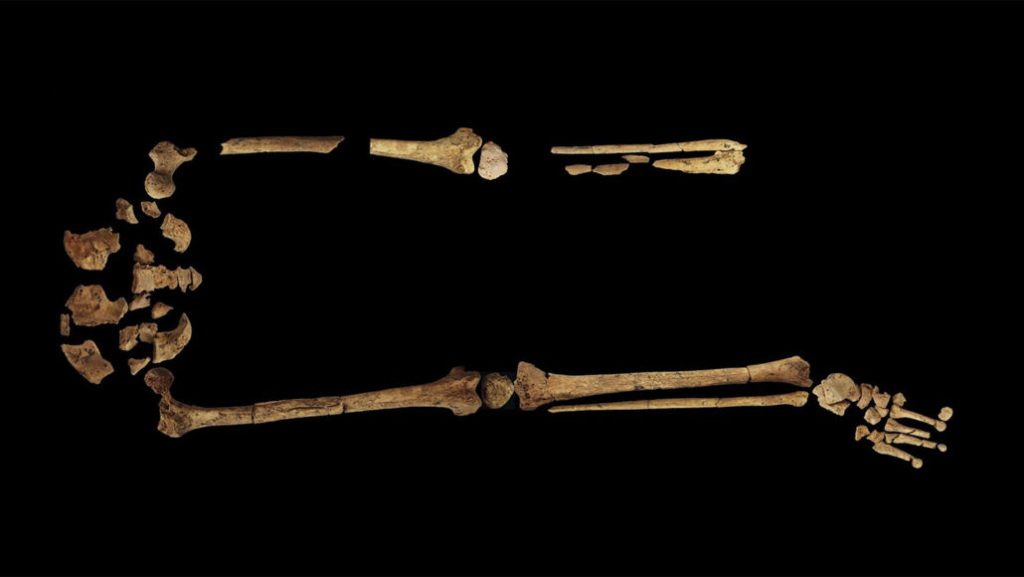
A child who lived on the Indonesian island of Borneo around 31,000 years ago underwent the oldest known surgical operation, an amputation of the lower left leg, researchers say.
One or more hunter-gatherers who performed the operation possessed detailed knowledge of human anatomy and considerable technical skill, enabling the youngster to avoid fatal blood loss and infection, say archaeologist Tim Maloney of Griffith University in Southport, Australia, and colleagues.
Healed bone where the lower leg was amputated indicates that the ancient youth survived for at least six to nine years after surgery before dying at age 19 or 20, the investigators report September 7 in Nature. Since there is no evidence of crushing from an accident or an animal’s bite at the amputation site, the researchers suspect that an unidentified medical problem led to the operation. Maloney’s team excavated this individual’s remains in 2020 from a grave inside a large, three-chambered cave. Radiocarbon dating of burned bits of wood just below the grave along with another dating technique on a tooth from the youth’s lower jaw let the researchers estimate when the surgery took place.
Until now, the oldest known amputation involved a farmer from France whose left forearm was surgically removed nearly 7,000 years ago. In North Africa, surgeries to create skull openings may have occurred as early as 13,000 years ago (SN: 3/31/22).
Faced with rapid wound infections in a tropical region, ancient people on Borneo developed antiseptic treatments from local plants, Maloney’s group suspects. It’s unknown what type of tool was used in the Stone Age operation or whether the patient was sedated with a plant-based concoction.
In Tom Edison’s Shaggy Dog, a short story by Kurt Vonnegut, Thomas Edison discovers that dogs are intellectually superior beings. They’re so smart, in fact, that the canines found the easiest possible way to survive: endearing themselves to humans. When Edison confronts his own dog about this revelation, the dog says, “Look, Mr. Edison. Why not keep quiet about this? It’s been working out to everybody’s satisfaction for hundreds of thousands of years. Let sleeping dogs lie.”
It’s true that humankind’s close relationship with canines spans millennia (SN: 7/18/17). This long-term interspecies friendship is a topic of intense scientific study, though where, when and even why it began remains murky (SN: 7/6/17). Short a talking dog, scientists have had to rely on archaeological and genetic evidence for clues (SN: 6/2/16). But the similarities between wolves and early domesticated dogs can make it challenging for researchers to tell them apart. In the earliest days, before wolves were fully domesticated, perhaps the most notable difference is simply the animals’ involvement with people. That’s where storytelling can help, says historian Julien d’Huy of the College of France in Paris. Our penchant for mythologizing canine companions may be just as ancient as our relationship with them, so d’Huy is turning to these stories in a bid to shed more light on the history of dog domestication.
Some historians argue that using mythology to track human migration and the spread of information is unreliable because stories change quickly (SN: 1/19/16). D’Huy disagrees: Dogs play a starring role in many cultural origin stories, and since these myths are central to identity, that gives them stability over time, he says.
“With mythology, we can have explanations of archaeology, we can have reasons for domestication, we can test hypotheses,” he says. D’Huy found three core storylines for the earliest myths related to dogs: The first links dogs with the afterlife, the second relates to the union of humans and dogs, and the third associates a dog with the star Sirius. Versions of these stories are found in many cultural regions around the world. He then borrowed statistical tools from biology to create family trees of myths, showing how the stories evolved as they followed humans from one region of the world to another.
Folktales about dogs stemmed from Central and Eastern Asia and spread to Europe, the Americas and later Australia and Africa, d’Huy reports in the June Anthropozoologica. This mythological travel route parallels a proposed path of dog domestication borne out by genetic and fossil evidence (SN: 3/1/21).
“This was a surprise,” d’Huy says. He wasn’t sure if dogs and our mythology about them would migrate together.
“It is certainly arguable that dogs were first domesticated in Asia,” says Pat Shipman, a retired paleoanthropologist and author of Our Oldest Companions: The Story of the First Dogs. Using mythology is a clever way to peer into the past, she says, because it can provide insight into how ancient humans valued dogs.
The prevalence of ancient myths identifying dogs as guides to the afterlife hint that our ancestors initially domesticated wolves not for hunting partners, as commonly believed, but for spiritual and symbolic reasons, d’Huy argues. This hypothesis fits with certain archaeological finds, he says, such as a 14,000-year-old grave in Germany containing a couple and two dogs. The woman was found with her hand resting on one of the dogs’ heads.
D’Huy is applying these methods to study how ancient myths can inform what we know about our connection with other animals such as sheep — their mythological link with the sun could have led to domestication. Symbolic, rather than utilitarian, reasons for domestication could explain a lot of data, he says.
“Comparative mythology has something to say in the world of research,” he says. “Something very precious to say, I think.”
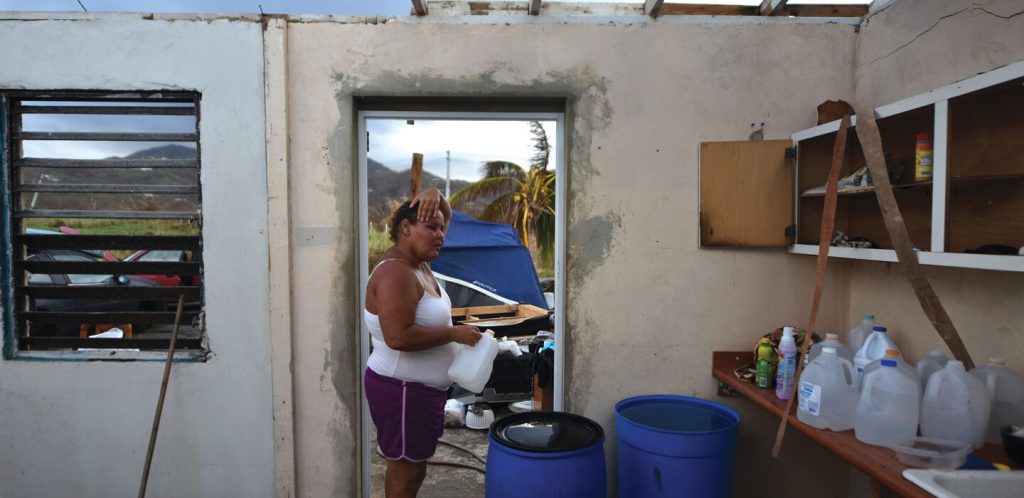
Hurricane Maria struck the island of Puerto Rico early on September 20, 2017, with 250-kilometer-per-hour winds, torrential rains and a storm surge up to three meters high. In its wake: nearly 3,000 people dead, an almost yearlong power outage and over $90 billion in damages to homes, businesses and essential infrastructure, including roads and bridges.
Geologist and diver Milton Carlo took shelter at his house in Cabo Rojo on the southwest corner of the island with his wife, daughter and infant grandson. He watched the raging winds of the Category 4 hurricane lift his neighbor’s SUV into the air, and remembers those hours as some of the worst of his life. For weeks, the rest of the world was in the dark about the full extent of the devastation, because Maria had destroyed the island’s main weather radar and almost all cell phone towers.
Far away on the U.S. West Coast, in Santa Cruz, Calif., oceanographer Olivia Cheriton watched satellite radar images of Maria passing over the instruments she and her U.S. Geological Survey team had anchored a few kilometers southwest of Puerto Rico. The instruments, placed offshore from the seaside town of La Parguera, were there to track pollution circulating around some of the island’s endangered corals.
More than half a year went by before she learned the improbable fate of those instruments: They had survived and had captured data revealing hurricane-related ocean dynamics that no scientist had ever recorded.
The wind-driven coastal currents interacted with the seafloor in a way that prevented Maria from drawing cold water from the depths of the sea up to the surface. The sea surface stayed as warm as bathwater. Heat is a hurricane’s fuel source, so a warmer sea surface leads to a more intense storm. As Cheriton figured out later, the phenomenon she stumbled upon likely played a role in maintaining Maria’s Category 4 status as it raked Puerto Rico for eight hours.
“There was absolutely no plan to capture the impact of a storm like Maria,” Cheriton says. “In fact, if we somehow could’ve known that a storm like that was going to occur, we wouldn’t have put hundreds of thousands of dollars’ worth of scientific instrumentation in the water.”
A storm’s path is guided by readily observable, large-scale atmospheric features such as trade winds and high-pressure zones. Its intensity, on the other hand, is driven by weather events inside the hurricane and wave action deep below the ocean’s surface. The findings by Cheriton and colleagues, published May 2021 in Science Advances, help explain why hurricanes often get stronger before making landfall and can therefore help forecasters make more accurate predictions.
Reef pollution Cheriton’s original research objective was to figure out how sea currents transport polluted sediments from Guánica Bay — where the Lajas Valley drains into the Caribbean Sea — to the pristine marine ecosystems 10 kilometers west in La Parguera Natural Reserve, famous for its bioluminescent waters.
Endangered elkhorn and mountainous star corals, called “the poster children of Caribbean reef decline” by marine geologist Clark Sherman, live near shore in some of the world’s highest recorded concentrations of now-banned industrial chemicals. Those polychlorinated biphenyls, or PCBs, hinder coral reproduction, growth, feeding and defensive responses, says Sherman, of the University of Puerto Rico–Mayagüez. Half of corals in the Caribbean have died since monitoring began in the 1970s, and pollution is a major cause, according to an April 2020 study in Science Advances. Of particular interest to Cheriton, Sherman and their colleagues was whether the pollution had reached deepwater, or mesophotic, reefs farther offshore, which could be a refuge for coral species that were known to be dying in shallower areas.
The main artery for this pollution is the Rio Loco — which translates to “Crazy River.” It spews a toxic runoff of eroded sediments from the Lajas Valley’s dirt roads and coffee plantations into Guánica Bay, which supports a vibrant fishing community. Other possible contributors to the pollution — oil spills, a fertilizer plant, sewage and now-defunct sugar mills — are the subject of investigations by public health researchers and the U.S. Environmental Protection Agency.
In June 2017, the team convened in La Parguera to install underwater sensors to measure and track the currents in this threatened marine environment. From Sherman’s lab on a tiny islet overrun with iguanas the size of house cats, he and Cheriton, along with team leader and USGS research geologist Curt Storlazzi and USGS physical scientist Joshua Logan, launched a boat into choppy seas. At six sites near shore, Storlazzi, Sherman and Logan dove to the seafloor and used epoxy to anchor pressure gauges and batonlike current meters. Together the instruments measured hourly temperature, wave height and current speed. The team then moved farther offshore where the steep island shelf drops off at a 45-degree angle to a depth of 60 meters, but the heavy ocean chop scuttled their efforts to install instruments there. For help working in the difficult conditions, Sherman enlisted two expert divers for a second attempt: Carlo, the geologist and diving safety officer, and marine scientist Evan Tuohy, both of the University of Puerto Rico–Mayagüez. The two were able to install the most important and largest piece, a hydroacoustic instrument comprising several drums fastened to a metal grid, which tracked the direction and speed of currents every minute using pulsating sound waves. A canister containing temperature and salinity sensors took readings every two minutes. Above this equipment, an electric thermometer extended to within 12 meters of the surface, registering temperature every five meters vertically every few seconds.
Working in concert, the instruments gave a high-resolution, seafloor-to-surface snapshot of the ocean’s hydrodynamics on a near-continuous basis. The equipment had to sit level on the sloping seafloor so as not to skew the measurements and remain firmly in place. Little did the researchers know that the instruments would soon be battered by one of the most destructive storms in history. Becoming Maria The word hurricane derives from the Caribbean Taino people’s Huricán, god of evil. Some of the strongest of these Atlantic tropical cyclones begin where scorching winds from the Sahara clash with moist subtropical air over the island nation of Cape Verde off western Africa. The worst of these atmospheric disturbances create severe thunderstorms with giant cumulonimbus clouds that flatten out against the stratosphere. Propelled by the Earth’s rotation, they begin to circle counterclockwise around each other — a phenomenon known as the Coriolis effect.
Weather conditions that summer had already spawned two monster hurricanes: Harvey and Irma. By late September, the extremely warm sea surface — 29º Celsius or hotter in some places — gave up its heat energy by way of evaporation into Maria’s rushing winds. All hurricanes begin as an area of low pressure, which in turn sucks in more wind, accelerating the rise of hot air, or convection. Countervailing winds known as shear can sometimes topple the cone of moist air spiraling upward. But that didn’t happen, so Maria continued to grow in size and intensity.
Meteorologists hoped that Maria would lose force as it moved across the Caribbean, weakened by the wake of cooler water Irma had churned up two weeks earlier. Instead, Maria tracked south, steaming toward the eastern Caribbean island of Dominica. Within 15 hours of making landfall, its maximum sustained wind speed doubled, reaching a house-leveling 260 kilometers per hour. That doubling intensified the storm from a milder (still dangerous) Category 1 to a strong Category 5.
NOAA’s computer forecasting models did not anticipate such rapid intensification. Irma had also raged with unforeseen intensity.
After striking Dominica hard, Maria’s eyewall broke down, replaced by an outer band of whipping thunderstorms. This slightly weakened Maria to 250 kilometers per hour before it hit Puerto Rico, while expanding the diameter of the storm’s eyewall — the area of strong winds and heaviest precipitation — to 52 kilometers. That’s close to the width of the island. It’s still not fully understood why Maria had suddenly gone berserk. Various theories point to the influence of hot towers — convective bursts of heat energy from thunderclouds that punch up into the stratosphere — or deep warm pools, buoyant freshwater eddies spilling out of the Amazon and Orinoco rivers into the Atlantic, where currents carry these pockets of hurricane-fueling heat to the Gulf of Mexico and the Caribbean Sea.
But even though these smaller-scale events may have a big impact on intensity, they aren’t fully accounted for in weather models, says Hua Leighton, a scientist at the National Oceanic and Atmospheric Administration’s hurricane research division and the University of Miami’s Cooperative Institute for Marine and Atmospheric Studies. Leighton develops forecasting models and investigates rapid intensification of hurricanes.
“We cannot measure everything in the atmosphere,” Leighton says.
Without accurate data on all the factors that drive hurricane intensity, computer models can’t easily predict when the catalyzing events will occur, she says. Nor can models account for everything that happens inside the ocean during a hurricane. They don’t have the data.
Positioning instruments just before a hurricane hits is a major challenge. But NOAA is making progress. It has launched a new generation of hurricane weather buoys in the western North Atlantic and remote control surface sensors called Saildrones that examine the air-sea interface between hurricanes and the ocean (SN: 6/8/19, p. 24).
Underwater, NOAA uses other drones, or gliders, to profile the vast areas regularly traversed by tropical storms. These gliders collected 13,200 temperature and salinity readings in 2020. By contrast, the instruments that the team set in Puerto Rico’s waters in 2017 collected over 250 million data points, including current velocity and direction — a rare and especially valuable glimpse of hurricane-induced ocean dynamics at a single location.
A different view After the storm passed, Storlazzi was sure the hurricane had destroyed his instruments. They weren’t designed to take that kind of punishment. The devices generally work in much calmer conditions, not the massive swells generated by Maria, which could increase water pressure to a level that would almost certainly crush instrument sensors.
But remarkably, the instruments were battered but not lost. Sherman, Carlo and Touhy retrieved them after Maria passed and put them in crates awaiting the research group’s return. When Storlazzi and USGS oceanographer Kurt Rosenberger pried open the instrument casings in January 2018, no water gushed out. Good sign. The electronics appeared intact. And the lithium batteries had powered the rapid-fire sampling enterprise for the entire six-month duration. The researchers quickly downloaded a flood of data, backed it up and started transmitting it to Cheriton, who began sending back plots and graphs of what the readings showed.
Floodwaters from the massive rains brought by Maria had pushed a whole lot of polluted sediment to the reefs outside Guánica Bay, spiking PCB concentrations and threatening coral health. As of a few months after the storm, the pollution hadn’t reached the deeper reefs.
Then the researchers realized that their data told another story: what happens underwater during a massive hurricane. They presumed that other researchers had previously captured a profile of the churning ocean depths beneath a hurricane at the edge of a tropical island.
Remarkably, that was not the case.
“Nobody’s even measured this, let alone reported it in any published literature,” Cheriton says. The team began to explore the hurricane data not knowing where it might lead.
“What am I looking at here?” Cheriton kept asking herself as she plotted and analyzed temperature, current velocity and salinity values using computer algorithms. The temperature gradient that showed the ocean’s internal or underwater waves was different than anything she’d seen before. During the hurricane, the top 20 meters of the Caribbean Sea had consistently remained at or above 26º C, a few degrees warmer than the layers beneath. But the surface waters should have been cooled if, as expected, Maria’s winds had acted like a big spoon, mixing the warm surface with cold water stirred up from the seafloor 50 to 80 meters below. Normally, the cooler surface temperature restricts the heat supply, weakening the hurricane. But the cold water wasn’t reaching the surface.
To try to make sense of what she was seeing, Cheriton imagined herself inside the data, in a protective bubble on the seafloor with the instruments as Maria swept over. Storlazzi worked alongside her analyzing the data, but focused on the sediments circulating around the coral reefs.
Cheriton was listening to “An Awesome Wave” by indie-pop band Alt-J and getting goosebumps while the data swirled before them. Drawing on instincts from her undergraduate astronomy training, she focused her mind’s eye on a constellation of data overhead and told Storlazzi to do the same.
“Look up Curt!” she said.
Up at the crest of the island shelf, where the seafloor drops off, the current velocity data revealed a broad stream of water gushing from the shore at almost 1 meter per second, as if from a fire hose. Several hours before Maria arrived, the wind-driven current had reversed direction and was now moving an order of magnitude faster. The rushing surface water thus became a barrier, trapping the cold water beneath it.
As a result, the surface stayed warm, increasing the force of the hurricane. The cooler layers below then started to pile up vertically into distinct layers, one on top of the other, beneath the gushing waters above.
Cheriton calculated that with the fire hose phenomenon the contribution from coastal waters in this area to Maria’s intensity was, on average, 65 percent greater, compared with what it would have been otherwise. Oceanographer Travis Miles of Rutgers University in New Brunswick, N.J., who was not involved in the research, calls Cheriton and the team’s work a “frontier study” that draws researchers’ attention to near-shore processes. Miles can relate to Cheriton and her team’s accidental hurricane discovery from personal experience: When his water quality–sampling gliders wandered into Hurricane Irene’s path in 2011, they revealed that the ocean off the Jersey Shore had cooled in front of the storm. Irene’s onshore winds had induced seawater mixing across the broad continental shelf and lowered sea surface temperatures.
The Puerto Rico data show that offshore winds over a steep island shelf produced the opposite effect and should help researchers better understand storm-induced mixing of coastal areas, says NOAA senior scientist Hyun-Sook Kim, who was not involved in the research. It can help with identifying deficiencies in the computer models she relies on when providing guidance to storm-tracking meteorologists at the National Hurricane Center in Miami and the Joint Typhoon Warning Center in Hawaii.
And the unexpected findings also could help scientists get a better handle on coral reefs and the role they play in protecting coastlines. “The more we study the ocean, especially close to the coast,” Carlo says, “the more we can improve conditions for the coral and the people living on the island.”
When it comes to hoisting water, plants are real power lifters.
For a tall tree, slurping hundreds of liters of water each day up to its leaves or needles, where photosynthesis takes place, can be quite a haul. Even for short grasses and shrubs, rising sap must somehow overcome gravity and resistance from plant tissues. Now, a first-of-its-kind study has estimated the power needed to lift sap to plants’ foliage worldwide — and it’s a prodigious amount, almost as much as all hydroelectric power generated globally. Over the course of a year, plants harness 9.4 quadrillion watt-hours of sap-pumping power, climatologist Gregory Quetin and colleagues report August 17 in the Journal of Geophysical Research: Biogeosciences. That’s about 90 percent of the amount of hydroelectric power produced worldwide in 2019.
Evaporation of water from foliage drives the suction that pulls sap upward, says Quetin, of the University of California, Santa Barbara (SN: 3/24/22). To estimate the total evaporative power for all plants on Earth annually, the team divided up a map of the world’s land area into cells that span 0.5° of latitude by 0.5° of longitude and analyzed data for the mix of plants in each cell that were actively pumping sap each month. The power required was highest, unsurprisingly, in tree-rich areas, especially in the rainforests of the tropics. If plants in forest ecosystems had to tap their own energy stores rather than rely on evaporation to pump sap, they’d need to expend about 14 percent of the energy they generated via photosynthesis, the researchers found. Grasses and other plants in nonforest ecosystems would need to expend just over 1 percent of their energy stores, largely because such plants are far shorter and have less resistance to the flow of sap within their tissues than woody plants do.
On sunny summer days, powerboats pulling water-skiers zip across Georgia’s Lake Oconee, a reservoir located about an hour-and-a-half drive east of Atlanta. For those without a need for speed, fishing beckons.
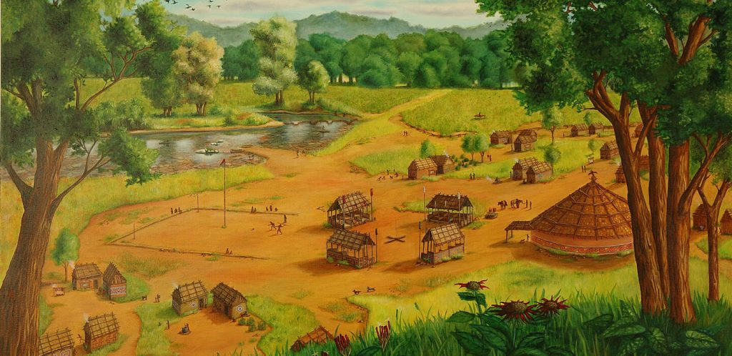
Little do the lake’s visitors suspect that here lie the remains of a democratic institution that dates to around 500 A.D., more than 1,200 years before the founding of the U.S. Congress.
Reservoir waters, which flooded the Oconee Valley in 1979 after the construction of a nearby dam, partly cover remnants of a 1,500-year-old plaza once bordered by flat-topped earthen mounds and at least three large, circular buildings. Such structures, which have been linked to collective decision making, are known from other southeastern U.S. sites that date to as early as around 1,000 years ago. At the Oconee site, called Cold Springs, artifacts were excavated before the valley became an aquatic playground. Now, new older-than-expected radiocarbon dates for those museum-held finds push back the origin of democratic institutions in the Americas several centuries, a team led by archaeologist Victor Thompson of the University of Georgia in Athens reported May 18 in American Antiquity.
Institutions such as these highlight a growing realization among archaeologists that early innovations in democratic rule emerged independently in many parts of the world. In specific, these findings add to evidence that Native American institutions devoted to promoting broad participation in political decisions emerged in various regions, including what’s now Canada, the United States and Mexico, long before 18th century Europeans took up the cause of democratic rule by the people.
That conclusion comes as no surprise to members of some Indigenous groups today. “Native people have been trying to convey for centuries that many communities have long-standing institutions [of] democratic and/or republican governance,” says University of Alberta archaeologist S. Margaret Spivey-Faulkner, a citizen of the Pee Dee Indian Nation of Beaver Creek in South Carolina.
Democratic innovations Scholars have traditionally thought that democracy — generally referring to rule by the people, typically via elected representatives — originated around 2,500 years ago in Greece before spreading elsewhere in Europe. From that perspective, governments in the Americas that qualified as democratic didn’t exist before Europeans showed up.
That argument is as misguided as Christopher Columbus’ assumption that he had arrived in East India, not the Caribbean, in 1492, says archaeologist Jacob Holland-Lulewicz of Penn State, a coauthor of the Cold Springs report. Institutions that enabled representatives of large communities to govern collectively, without kings or ruling chiefs, characterized an unappreciated number of Indigenous societies long before the Italian explorer’s fateful first voyage, Holland-Lulewicz asserts.
In fact, collective decision-making arrangements that kept anyone from amassing too much power and wealth go back thousands, and probably tens of thousands of years in many parts of the world (SN: 11/9/21). The late anthropologist David Graeber and archaeologist David Wengrow of University College London describe evidence for that scenario in their 2021 book The Dawn of Everything.
But only in the last 20 years have archaeologists begun to take seriously claims that ancient forms of democratic rule existed. Scientific investigations informed by Indigenous partners will unveil past political realities “most of us in Indian country take for granted,” Spivey-Faulkner says.
Early consensus Thompson’s Cold Springs project shows how such a partnership can work.
Ancestors of today’s Muscogee people erected Cold Springs structures within their original homelands, which once covered a big chunk of southeastern North America before the government-forced exodus west along the infamous Trail of Tears. Three members of the Muscogee Nation’s Department of Historic and Cultural Preservation in Okmulgee, Okla., all study coauthors, provided archaeologists with first-hand knowledge of Muscogee society. They emphasized to the researchers that present-day Muscogee councils where open debate informs consensus decisions carry on a tradition that goes back hundreds of generations.
A set of 44 new radiocarbon dates going back 1,500 years for material previously unearthed at the Georgia site, including what were likely interior posts from some structures, then made perfect sense. Earlier analyses in the 1970s of excavated pottery and six radiocarbon dates from two earthen mounds at Cold Springs suggested that they had been constructed at least 1,000 years ago.
Based on the new dating, Thompson’s team found that from roughly 500 A.D. to 700 A.D, Indigenous people at Cold Springs constructed not only earthen mounds but at least three council-style roundhouses — each 12 to 15 meters in diameter — and several smaller structures possibly used as temporary housing during meetings and ceremonies.
Small communities spread across the Oconee Valley formed tight-knit social networks called clans that gathered at council houses through the 1700s, Thompson’s group suspects. Spanish expeditions through the region from 1539 to 1543 did not cause those societies and their traditions to collapse, as has often been assumed, the researchers contend. Excavations and radiocarbon dating at another Oconee Valley Muscogee site called Dyar support that view. A square ground connected to Dyar includes remains of a council house. Activity at the site began as early as 1350 and continued until as late as about 1670, or about 130 years after first encounters with the Spanish, Holland-Lulewicz and colleagues reported in the October 2020 American Antiquity.
Spanish historical accounts mistakenly assumed that powerful chiefs ran Indigenous communities in what have become known as chiefdoms. Many archaeologists have similarly, and just as wrongly, assumed that starting around 1,000 years ago, chiefs monopolized power in southeastern Native American villages, the scientists argue.
Today, members of the Muscogee (Creek) Nation in Oklahoma gather, sometimes by the hundreds or more, in circular structures called council houses to reach collective decisions about various community issues. Council houses typically border public square grounds. That’s a modern-day parallel to the story being told by the ancient architecture at Cold Springs.
“Muscogee councils are the longest-surviving democratic institution in the world,” Holland-Lulewicz says.
Indigenous influencers Political consensus building by early Muscogee people didn’t occur in a vacuum. Across different regions of precontact North America, institutions that enabled broad participation in democratic governing characterized Indigenous societies that had no kings, central state governments or bureaucracies, Holland-Lulewicz and colleagues, report March 11 in Frontiers in Political Science.
The researchers dub such organizations keystone institutions. Representatives of households, communities, clans and religious societies, to name a few, met on equal ground at keystone institutions. Here, all manner of groups and organizations followed common rules to air their opinions and hammer out decisions about, say, distributing crops, organizing ceremonial events and resolving disputes. For example, in the early 1600s, nations of the neighboring Wendat (Huron) and Haudenosaunee people in northeastern North America had formed political alliances known as confederacies, says coauthor Jennifer Birch, a University of Georgia archaeologist. Each population contained roughly 20,000 to 30,000 people. Despite their size, these confederacies did not hold elections in which individuals voted for representatives to a central governing body. Governing consisted of negotiations among intertwined segments of society orchestrated by clans, which claimed members across society.
Clans, in which membership was inherited through the female line, were — and still are — the social glue holding together Wendat (Huron) and Haudenosaunee politics. Residents of different villages or nations among, say, the Haudenosaunee, could belong to the same clan, creating a network of social ties. Excavations of Indigenous villages in eastern North America suggest that the earliest clans date to at least 3,000 years ago, Birch says.
Within clans, men and women held separate council meetings. Some councils addressed civil affairs. Others addressed military and foreign policy, typically after receiving counsel from senior clan women.
Clans controlled seats on confederacy councils of the Wendat and Haudenosaunee. But decisions hinged on negotiation and consensus. A member of a particular clan had no right to interfere in the affairs of any other clan. Members of villages or nations could either accept or reject a clan leader as their council representative. Clans could also join forces to pursue political or military objectives.
Some researchers, including Graeber and Wengrow, suspect a Wendat philosopher and statesman named Kandiaronk influenced ideas about democracy among Enlightenment thinkers in France and elsewhere. A 1703 book based on a French aristocrat’s conversations with Kandiaronk critiqued authoritarian European states and provided an Indigenous case for decentralized, representative governing.
Although Kandiaronk was a real person, it’s unclear whether that book presented his actual ideas or altered them to resemble what Europeans thought of as a “noble savage,” Birch says.
Researchers also debate whether writers of the U.S. Constitution were influenced by how the Haudenosaunee Confederacy distributed power among allied nations. Benjamin Franklin learned about Haudenosaunee politics during the 1740s and 1750s as colonists tried to establish treaties with the confederacy.
Colonists took selected political ideas from the Haudenosaunee Confederacy without grasping its underlying cultural concerns, says University of Alberta anthropological archaeologist Kisha Supernant, a member of an Indigenous population in Canada called Métis. The U.S. Constitution stresses individual freedoms, whereas the Indigenous system addresses collective responsibilities to manage the land, water, animals and people, she says.
Anti-Aztec equality If democratic institutions are cultural experiments in power sharing, one of the most interesting examples emerged around 700 years ago in central Mexico.
In response to growing hostilities from surrounding allies of the Aztec Empire, a multi-ethnic confederation of villages called Tlaxcallan built a densely occupied city of the same name. When Spaniards arrived in 1519, they wrote of Tlaxcallan as a city without kings, rulers or wealthy elites. Until the last decade, Mexican historians had argued that Tlaxcallan was a minor settlement, not a city. They dismissed historical Spanish accounts as exaggerations of the newcomers’ exploits.
Opinions changed after a team led by archaeologist Lane Fargher of Mexico’s Centro de Investigación y Estudios Avanzados del Instituto Polytécnico Nacional (Cinvestav del IPN) in Merida surveyed and mapped visible remains of Tlaxcallan structures from 2007 to 2010. Excavations followed from 2015 through 2018, revealing a much larger and denser settlement than previously suspected.
The ancient city covers a series of hilltops and hillsides, Fargher says. Large terraces carved out of hillsides supported houses, public structures, plazas, earthen mounds and roadways. Around 35,000 people inhabited an area of about 4.5 square kilometers in the early 1500s.
Artifacts recovered at plazas indicate that those open spaces hosted commercial, political and religious activities. Houses clustered around plazas. Even the largest residences were modest in size, not much larger than the smallest houses. Palaces of kings and political big shots in neighboring societies, including the Aztecs, dwarfed Tlaxcallan houses. Excavations and Spanish accounts add up to a scenario in which all Tlaxcallan citizens could participate in governmental affairs. Anyone known to provide good advice on local issues could be elected by their neighbors in a residential district to a citywide ruling council, or senate, consisting of between 50 and 200 members. Council meetings were held at a civic-ceremonial center built on a hilltop about one kilometer from Tlaxcallan.
As many as 4,000 people attended council meetings regarding issues of utmost importance, such as launching military campaigns, Fargher says.
Those chosen for council positions had to endure a public ceremony in which they were stripped naked, shoved, hit and insulted as a reminder that they served the people. Political officials who accumulated too much wealth could be publicly punished, replaced or even killed.
Tlaxcallan wasn’t a social utopia. Women, for instance, had limited political power, possibly because the main route to government positions involved stints of military service. But in many ways, political participation at Tlaxcallan equaled or exceeded that documented for ancient Greek democracy, Fargher and colleagues reported March 29 in Frontiers of Political Science. Greeks from all walks of life gathered in public spaces to speak freely about political issues. But commoners and the poor could not hold the highest political offices. And again, women were excluded.
Good government Tlaxcallan aligned itself with Spanish conquerors against their common Aztec enemy. Then in 1545, the Spanish divided the Tlaxcallan state into four fiefdoms, ending Tlaxcallan’s homegrown style of democratic rule.
The story of this fierce, equality-minded government illustrates the impermanence of political systems that broadly distribute power, Fargher says. Research on past societies worldwide “shows us how bad the human species is at building and maintaining democratic governments,” he contends.
Archaeologist Richard Blanton of Purdue University and colleagues, including Fargher, analyzed whether 30 premodern societies dating to as early as around 3,000 years ago displayed signs of “good government.” An overall score of government quality included evidence of systems for providing equal justice, fair taxation, control over political officials’ power and a political voice for all citizens.
Only eight societies received high scores, versus 12 that scored low, Blanton’s group reported in the February 2021 Current Anthropology. The remaining 10 societies partly qualified as good governments. Many practices of societies scoring highest on good government mirrored policies of liberal democracies over the past century, the researchers concluded.
That’s only a partial view of how past governments operated. But surveys of modern nations suggest that no more than half feature strong democratic institutions, Fargher says.
Probing the range of democratic institutions that societies have devised over the millennia may inspire reforms to modern democratic nations facing growing income disparities and public distrust of authorities, Holland-Lulewicz suspects. Leaders and citizens of stressed democracies today might start with a course on power sharing in Indigenous societies. School will be in session at the next meeting of the Muscogee National Council.